
Part 1: 22nd Street Station

This is the first in a new series on bike rides you can do from New Westminster SkyTrain stations. Why New West? Because I like to ride and it’s a great city to discover on a bike. It’s a small city that’s packed with parks and historic sites, breweries, pubs, cafes, and even an urban winery. The city is on a hill, but it offers some fairly easy riding across the ridges as well as it mostly flat rides along the riverfront. (I don’t like hills either, so I’ve mapped out routes that minimize climbs.)
22nd Street station is the westernmost of New Westminster’s five SkyTrain stations, and situated close to the border of Burnaby and the Queensborough Bridge. It’s the best station to get off at for Queensborough and for riding over to Uptown and Queens Park.
Queensborough
Length: 17 km (less if you take the Q2Q ferry back instead of the bridge)
Terrain: Flat
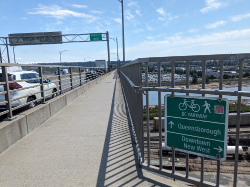
Right out of the gate of 22nd Street SkyTrain, head west and then take a left at the crosswalk to get on the bike path over the Queensborough Bridge. This ride takes you on a bit of a loop around Queensborough, dipping into Richmond for a taste of the marine life (and beer at Tugboat Annie’s) and back along mostly calm residential streets and off-street paths. If the Q2Q ferry is running, you could make this ride even easier by taking your bike on it back to River Market downtown instead of riding back and over the bridge. In any case, if you like the salty tang of boats and dream of life along the water, this is the ride for you.
There are plenty of places to pull out and rest with a view of the river—even Queensborough Landing Shopping Centre has a bike path running through it that leads to a little deck where you can see the bridge and log booms going by. (Tip: Bring panniers for shopping.)
Crosstown Greenway (7th Ave) to Moody Park/Uptown/Queens Park
Length: 7 km
Terrain: gentle rolling
This ride heads east from the station and along 7th Avenue. It goes (gently) uphill for the first part, until you reach the plateau of Moody Park and Uptown. It’s a somewhat traffic-calmed street with bike crossing buttons at the major intersections like 12th, 8th and 6th streets. This is a good ride for when you want to meander around and stop off for snacks, like the donairs and Lebanese food around 12th Street or the excellent Rocky Point Ice Cream near 6th Avenue and 5th Street.
Besides Moody Park, you might also take in the view from Grimston Park (close to the start of the ride) or loop through the mini-forest and gardens of Queen’s Park. The Queen’s Park neighbourhood is lovely to explore, full of heritage houses to admire as you roll by.
Finally, if you’re there on a Thursday afternoon, stop by the New West Farmers’ Market by Tipperary Park and eat some local goodies in the shade of the Japanese-inspired garden. You could cross Royal Avenue from there and ride downtown to end your ride, or ride back up to 7th Avenue and follow the Crosstown Greenway down to Sapperton to catch the train from there.
BC Parkway to Edmonds and South Burnaby
Distance: 9.5 km
Terrain: gentle rolling, with one big hill down
Edmonds is an unassuming area that doesn’t get any love from tourism guidebooks, but it has a few hidden gems, like adventure playgrounds, Indian food and an indoor sauna/spa complex with a Turkish hammam.
To start, head uphill on the BC Parkway path from 22nd Street station. Soon you’ll arrive at Taylor Park, a wide field with a bike skills park, zipline and swings. Enjoy the view, then continue up the path lined by blackberry bushes. You can keep going on the BC Parkway past Edmonds station and toward Metrotown, but for this ride, turn right at the first break in the bushes and cross the Griffiths Street overpass. Turn left, then right on 14th Ave. for a couple of blocks, then ride through the park to find your way back to 12th Avenue. 12th is marked as a bike route and has crossings for the major arterials of Kingsway, Canada Way and 6th Street (which has an abundance of Indian restaurants and groceries, as well as the aforementioned sauna/spa).
Though the suburban scenery and parks are pleasant, be aware that 12th Avenue can be a rat-runner route for cars. They’ll love you for hitting the crossing button at 2nd Street to go back down into New West (whee! hill!) but also cut you off.
Finish off this ride by going back up to 7th Avenue (Crosstown Greenway), up over the McBride overpass, and then back down along local streets into Sapperton. Enjoy the views of the Fraser River from the Fraser Cemetery, then turn right to go down Sherbrooke Street into Sapperton (another fine adventure park there in the shade). East Columbia Street offers restaurants, cafes, a pub and a fine Italian bakery (Fratelli) if you need some refreshments. You can get on the train at Sapperton, just below the hospital, or follow the Central Valley Greenway signs to Braid Station or to more Burnaby.
Burnaby Fraser Foreshore
Distance: 12 km+
Terrain: Downhill, then flat
This is another ride I think is underrated because it starts and ends in fairly industrialized areas, away from Vancouver’s downtown core, but if you’d like a riverside ride along relatively uncrowded trails and through several parks, come on down!
And I’ve just added it now because I only recently figured out a non-dangerous way to get to the Fraser Foreshore from 22nd Street Station. Despite what’s marked on bike maps/Google maps, you do not need to take the narrow bike lanes beside 70K+ traffic on Marine Way. Instead, head west along 7th Avenue from the station, which turns into Trapp Road at the Burnaby border. Go straight through the stop signs (stopping and looking, of course), down the hill (whee) and around the curve (wow, where’d this farm country come from?). Count 1, 2, 3 cross-streets and make a left onto 10th Ave. and ride down to the gap in the fence. You’ll find yourself right at the crosswalk for Marine Way when you go through the fence. And I mean right there because there’s no sidewalk and just a narrow bike lane and fast-moving traffic thisclose. So be careful.
Hit the crosswalk button to your right. As you cross Marine Way, you’ll see the paved, multi-use shared path on the left. Basically just follow this path (there’s a couple crossings/turns) until you reach the Fraser Foreshore park sign at the end of a cul-de-sac by the Burnaby Waste-to-Energy plant, where the asphalt turns to gravel. The area is industrial/business park-filled, so it’s fairly quiet on weekends and evenings, but watch for cars and tractor-trailers crossing driveways during the day.
And then there you are in the forest! Just follow the trail; if you end up in the river, you’ve gone too far, haha. Though it forks in places, it’s quite easy to follow the trail(s) west all the way to Vancouver. There are a few lookouts along the way to take in the view and watch the tugboats and log booms (a theme around these parts). And also a few restaurants to stop at, like Romers Burger Bar with it’s riverview patio or the strangely acclaimed Northern Café located above a lumber yard near the point where the pleasant riverside path gives way to way-less-pleasant East Kent Avenue (not Vancouver’s finest idea of a bike route…)
Where to go next? If you can tough it out, East Kent Ave will eventually lead you to the Marine Gateway Canada Line Station/bus loop. You could also choose to go south to Richmond and ride back along River Road for a view from the other shore, or ride back into Vancouver along any number of north-south routes (the slopes get a little easier after Knight Street). I would suggest nabbing a picnic table at the Milltown Bar and Grill to watch the planes landing and taking off from YVR and then hitting the Arbutus Greenway back to the city – if you have any energy left!
Map
View these four routes on Google maps:
Parts 2 and 3 now available: rides from New Westminster Station and Braid Station. Stay tuned, ride safe, see you out there.

1 Comment